
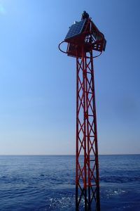
Emerging part of BOUSSOLE buoy in the Mediterrean Sea. Courtesy of Laboratoire Oceanographique de Villefranche (CNRS/LOV).
European Space Agency
is organizing an international workshop
Options for future European satellite OCR vicarious adjustment infrastructure for the Sentinel-3 OLCI and Sentinel-2 MSI series
on 21 – 23 February 2017 in ESA/ESRIN, Frascati, Italy
Click here for agenda and registration
Copernicus is a European system for monitoring the Earth. It includes Earth observation satellites, ground-based measurements and services to processes data to provide users with reliable and up-to-date information through a set of Copernicus Services related to environmental and security issues. Copernicus has developed the Sentinel-2 and Sentinel-3 family of satellites that carry complementary instruments to measure ocean colour in support of Copernicus services. The societal benefits of Ocean Colour Radiometry (OCR) are well articulated and include management of the marine ecosystem, role of the ocean ecosystem in climate change, aquaculture, fisheries, coastal zone water quality, mapping and monitoring harmful algal blooms amongst others. The Sentinel-2 Multi-Spectral Instrument (MSI) and the Sentinel-3 Ocean and Land Colour Imager (OLCI) represent state of the art for satellite OCR.
Satellite OCR are designed to retrieve the spectral distribution of upwelling radiance just above the sea surface (the water-leaving radiance) that is then used to estimate a number of geophysical parameters through the application of specific bio-optical algorithms. Atmospheric correction for ocean colour data is challenging and instrument design must therefore incorporate extremely sensitive and stable radiometry, dedicated on-board calibration and a large number of spectral channels. Once on-orbit, the uncertainty characteristics of: (a) the satellite instruments established during pre-launch laboratory calibration and characterisation activities and (b) the end-to-end geophysical measurement retrieval process can only be assessed via independent calibration and validation activities.
Satellite OCR relies on vicarious adjustment and therefore on the long-term availability of precise and accurate in situ measurements to ensure the expected Earth observation products accuracy. The European Space Agency (ESA) has launched a project caller Fiducial Reference Measurements for Satellite Ocean Colour (FRM4SOC, see http://www.frm4soc.org). Led by Tartu Observatory Estonia, FRM4SOC aims to establish and maintain SI traceability of Fiducial Reference Measurements (FRM) for satellite OCR. As part of this project, a 3-day workshop is being convened at ESA/ESRIN, Frascati, Italy on February 21st to 23rd 2017 to evaluate options for long-term future European satellite OCR vicarious adjustment infrastructure for the Sentinel-3 OLCI and Sentinel-2 MSI A/B/C and D instruments.
Further details including a preliminary program, registration and abstract submission tools (for oral and poster presentations) is available here.
For further information contact: Christophe.Lerebourg@acri-st.fr and Craig.Donlon@esa.int