
David Antoine, Curtin University
April 2017
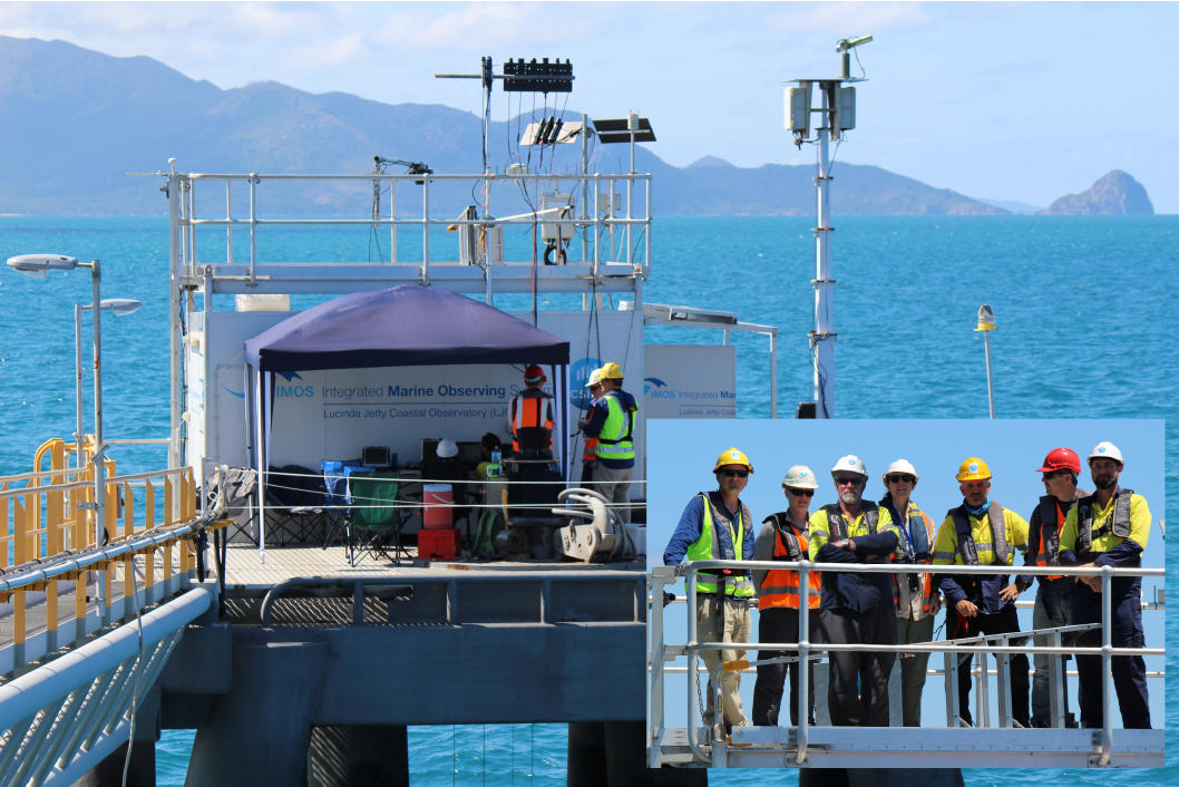
Figure 1. The Lucinda Jetty Coastal Observatory with field participants from right to left: M. Slivkoff, J. Lovell, D. Boadle, M. Doblin, B. Baker, D. Antoine, and T. Schroeder. Photo by D.Boadle.
Representatives of the Australian ocean colour remote sensing research community from Commonwealth Scientific and Industrial Research Organisation (CSIRO), Curtin University and University of Technology Sydney recently joined forces to investigate the experimental uncertainties associated with a variety of commonly used multi- and hyperspectral radiometers for the calculation of above-water remote sensing reflectance; a key parameter in ground-truthing ocean colour satellites and other bio-optical studies.
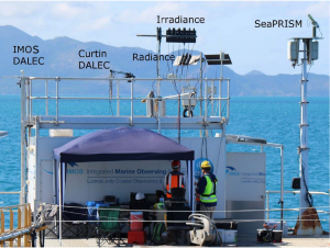
Figure 2. The Lucinda Jetty Coastal Observatory platform equipped with Radiometry Task Team Instrumentation. (Note IMOS DALEC is partially obscured by hand-railing). Photo by D.Boadle.
Accurate sea-truth radiometric measurements of ocean colour are required to monitor the temporal stability of airborne and space-based ocean colour sensors, as well as the accuracy of any atmospheric correction procedures applied to the remote sensing data. Thus, the accuracy of any sea truth radiometric measurements needs to be established.
In addition to ground-sensor performance, deployment and post-processing methodologies can contribute significantly to the overall accuracy of radiometric measurements. In Australia, there are a relatively small number of geographically isolated researchers and technicians that study ocean optics. They are from different backgrounds with different perspectives and use different instrumentation. The Integrated Marine Observing System (IMOS) 1-year funding provided the opportunity for a group of these researchers to form a Radiometry Task Team in which to compare their approaches.
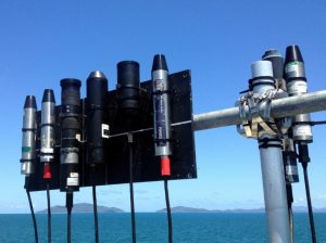
Figure 3. Irradiance radiometers lined up, with a view of Pelorus and Orpheus Islands in the background. 4 x Ramses, 2 x HyperOCR, 1 x USSIMO, and 1 x MS8 sensors are visible. Photo by M.Slivkoff.
First, the group pooled their sensors and sent them to a commercial radiometric calibration facility where lamp-based calibrations were performed for each sensor at 3 different internal temperatures encompassing the range of temperatures encountered in above-water Australian field conditions. Next, the task team inter-compared the calibrated instruments in the field at the IMOS/CSIRO funded Lucinda Jetty Coastal Observatory (LJCO) in tropical North Queensland. Situated at the end of a 5.76 km long bulk sugar loading facility, this unique location adjacent to the Great Barrier Reef World Heritage area exhibits a wide range of Great Barrier Reef water inherent optical property (IOP) throughout the year. Suspended some 20 meters above the ocean surface, the dedicated work platform has long-term IOP, SeaPRISM radiance and DALEC above water remote-sensing reflectance installations.
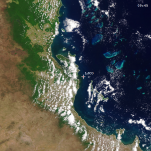
Figure 4. Pseudo true-colour image captured by Sentinel-3A OLCI over Lucinda Jetty during the RTT field inter-comparison on 9 Nov 2016. Credit: ESA, EUMETSAT, NOAA (OCView).
The task team assembled for a 2-day campaign (9-10 Nov 2016) in the beautiful fishing village of Dungeness; woke every morning to a view of the warm tropical mist-clad mountains of Hinchinbrook Island, looking past the invitingly glassy but crocodile-inhabited mangrove channel. After a 15-minute drive out over the jetty, the team performed consistent measurements for each of the radiance and irradiance device types, and two integrated DALEC above water reflectance systems and the autonomous SeaPRISM (Figs 2 and 3). The tropical solar zenith angles approaching one or two degrees at noon allowed observations of the cosine behaviour of the irradiance sensors over a large angular range.
Sky conditions were nearly ideal for the 2-day sampling period, with only a few wispy clouds in the morning, rapidly burning off in the hot tropical sun. The mornings were typically still and very humid until a sea breeze system developed, bringing wind speeds of 10 – 15 knots as measured by a permanently installed Vaisala Weather Transmitter (WXT520).
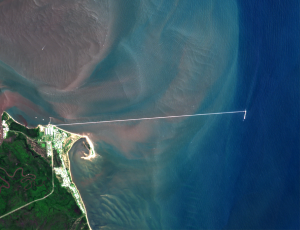
Figure 5. Zoom of the Sentinel-2A MSI RGB composite on 25 March 2017 from the same place. Credit: C.Donlon, ESA.
These hot conditions ensured that all sensors that recorded internal temperatures were reading 35+ degrees Celsius; far hotter than typical temperatures factory calibrations are performed at. Fortunately, pre-deployment calibrations were performed for all instruments at these elevated temperatures, so suitable instrument responsivities were applied to field data in order to achieve improved radiometric accuracy.
Measurements were occasionally perturbed by curious fishermen chasing the large fish which aggregated under the LJCO pylons, however this provided the team with occasional and often welcome breaks. Upon completion of the daily work, members of the team enjoyed supporting the local fishing industry by dining on a fine selection of food and rehydrating with local beverages.
The field deployment was an excellent chance for the often regionally separated researchers and technicians to meet, compare stories, and discuss methodologies and other technical considerations pertinent to ocean colour radiometry. With the ongoing processing and analysis of the datasets acquired in this study, the community is learning more about the experimental uncertainties and resultant confidence which can be placed in using field radiometers to validate aerial and satellite-based ocean colour remote measurements.
Here you can find information about IMOS (Integrated Marine Observing System) activities and the Australian Integrated Marine Observing System’s Radiometry Task Team.
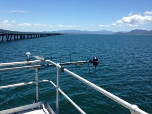
Figure 6. View of Lucinda Jetty towards Hinchinbrook Channel and the mainland. Photo by M. Slivkoff.
Figure 7. Typical view from the elevated work platform. Photo by M.Slivkoff.
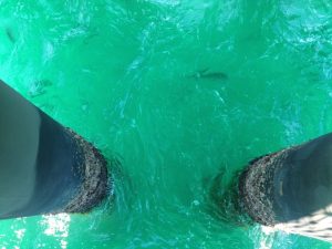
Figure 8. Many edible large (~1m) scaled particles circled the pylons for the duration of the experiment. Photo by M.Slivkoff.